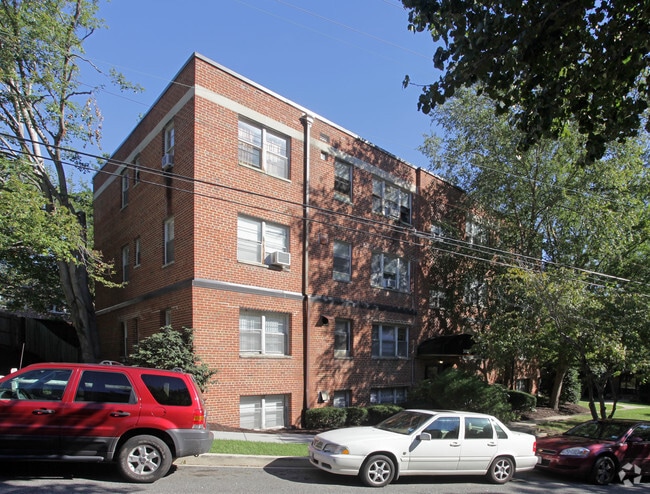
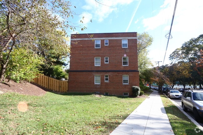
Property Record
3429 Yuma St Nw, Washington, DC 20008
NEARBY LISTINGS FOR SALE OR LEASE
Property Detail
3429 Yuma St Nw
Washington-Arlington-Alexandria, DC-VA-MD-WV
North Cleveland Park
1971-0027
SQUARE 1971 LOT 0027 NBHD: NORTH CLEVELAND PARK
Apartment
District of Columbia
X
District of Columbia
1100010004C
27
2025
0.87 AC
2025
Van Ness
001200
Washington, DC
32,324 SF
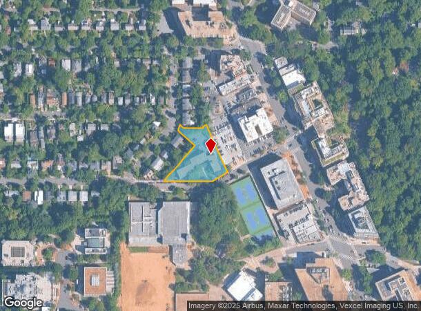
DEMOGRAPHICS near 3429 Yuma St Nw
1 Mile
3 Mile
5 Mile
2024 Total Population
25,326
275,097
659,127
2029 Population
22,786
251,309
620,516
Pop Growth 2024-2029
(10.03%)
(8.65%)
(5.86%)
Average Age
41
40
39
2024 Total Households
13,167
128,153
302,460
HH Growth 2024-2029
(10.96%)
(9.39%)
(6.54%)
Median Household Inc
$129,078
$123,193
$117,931
Avg Household Size
1.90
2.00
2.10
2024 Avg HH Vehicles
1.00
1.00
1.00
Median Home Value
$982,830
$901,272
$836,758
Median Year Built
1956
1949
1961
Nearby Places
Map Layers
Map Styles
 Street
 Aerial
- Restaurants
- Banks
- Shops
- Fitness
- Groceries
PUBLIC TRANSPORTATION
TRANSIT/SUBWAY
Van Ness-Udc (Red Line - Washington Metropolitan Area Transit Authority Metrorail (Metrorail))
DRIVE
WALK
Distance
Van Ness-Udc (Red Line - Washington Metropolitan Area Transit Authority Metrorail (Metrorail))
1 min
8 min
0.4 mi
Tenleytown-Au (Red Line - Washington Metropolitan Area Transit Authority Metrorail (Metrorail))
DRIVE
WALK
Distance
Tenleytown-Au (Red Line - Washington Metropolitan Area Transit Authority Metrorail (Metrorail))
3 min
15 min
0.8 mi
Cleveland Park (Red Line - Washington Metropolitan Area Transit Authority Metrorail (Metrorail))
DRIVE
WALK
Distance
Cleveland Park (Red Line - Washington Metropolitan Area Transit Authority Metrorail (Metrorail))
3 min
20 min
1.1 mi
COMMUTER RAIL
Silver Spring (BRUNSWICK - WASHINGTON - Maryland Area Regional Commuter Trains (The MARC), Brunswick Line - Maryland Area Regional Commuter Trains (The MARC))
DRIVE
WALK
Distance
Silver Spring (BRUNSWICK - WASHINGTON - Maryland Area Regional Commuter Trains (The MARC), Brunswick Line - Maryland Area Regional Commuter Trains (The MARC))
12 min
5.7 mi
Lead (Fredericksburg Line - Virginia Railway Express, Manassas Line - Virginia Railway Express)
DRIVE
WALK
Distance
Lead (Fredericksburg Line - Virginia Railway Express, Manassas Line - Virginia Railway Express)
13 min
6.2 mi
AIRPORT
Ronald Reagan Washington Ntl
DRIVE
WALK
Distance
Ronald Reagan Washington Ntl
19 min
9.0 mi
Washington Dulles International
DRIVE
WALK
Distance
Washington Dulles International
45 min
24.1 mi
Baltimore/Washington International Thurgood Marshall
DRIVE
WALK
Distance
Baltimore/Washington International Thurgood Marshall
50 min
36.0 mi
Freight Ports
Port of Baltimore
DRIVE
WALK
Distance
Port of Baltimore
55 min
38.8 mi
Nearby Properties
Address
Land Use
TOTAL SIZE
Lot Size
Zoning
Address
Land Use
TOTAL SIZE
Lot Size
Zoning
553,914 SF
55.91 AC
R-1B
Address
Land Use
TOTAL SIZE
Lot Size
Zoning
900,000 SF
12.60 AC
RA-4
Address
Land Use
TOTAL SIZE
Lot Size
Zoning
77.26 AC
R-3/GT
Address
Land Use
TOTAL SIZE
Lot Size
Zoning
247,900 SF
170.58 AC
RA-2;UNZON
Address
Land Use
TOTAL SIZE
Lot Size
Zoning
Address
Land Use
TOTAL SIZE
Lot Size
Zoning
795,214 SF
MU-5A
Address
Land Use
TOTAL SIZE
Lot Size
Zoning
1,095,275 SF
30.70 AC
MU-4;RA-2
Address
Land Use
TOTAL SIZE
Lot Size
Zoning
997,890 SF
6.30 AC
CR3.0
Address
Land Use
TOTAL SIZE
Lot Size
Zoning
1,452,667 SF
43.94 AC
R-1B;RA-1
Address
Land Use
TOTAL SIZE
Lot Size
Zoning
10,158 SF
97.34 AC
MU-10;MU-1
Address
Land Use
TOTAL SIZE
Lot Size
Zoning
256,187 SF
8.97 AC
RA-2
Address
Land Use
TOTAL SIZE
Lot Size
Zoning
902,764 SF
2.87 AC
MU-5A
Address
Land Use
TOTAL SIZE
Lot Size
Zoning
1,180,000 SF
35.70 AC
R90
Address
Land Use
TOTAL SIZE
Lot Size
Zoning
579,243 SF
1.89 AC
CR8.0
Address
Land Use
TOTAL SIZE
Lot Size
Zoning
399,180 SF
0.46 AC
D-5
Address
Land Use
TOTAL SIZE
Lot Size
Zoning
401,625 SF
1.23 AC
MU-6B
Address
Land Use
TOTAL SIZE
Lot Size
Zoning
362,643 SF
CR
Address
Land Use
TOTAL SIZE
Lot Size
Zoning
528 SF
296.59 AC
MU-11;MU-1
Address
Land Use
TOTAL SIZE
Lot Size
Zoning
1,237,319 SF
4.37 AC
RA-4
Address
Land Use
TOTAL SIZE
Lot Size
Zoning
244,615 SF
19.61 AC
R-1A/FH
Address
Land Use
TOTAL SIZE
Lot Size
Zoning
69.17 AC
R-1B
Address
Land Use
TOTAL SIZE
Lot Size
Zoning
930,240 SF
2.32 AC
CR3.0
Address
Land Use
TOTAL SIZE
Lot Size
Zoning
505,408 SF
12.46 AC
RA-1
Address
Land Use
TOTAL SIZE
Lot Size
Zoning
520,000 SF
2.65 AC
MU-10;RA-5
Address
Land Use
TOTAL SIZE
Lot Size
Zoning
287,183 SF
0.59 AC
CR5
Address
Land Use
TOTAL SIZE
Lot Size
Zoning
516,328 SF
13.19 AC
R-1B
Address
Land Use
TOTAL SIZE
Lot Size
Zoning
316,393 SF
13.61 AC
R-1A
Address
Land Use
TOTAL SIZE
Lot Size
Zoning
644,235 SF
1.67 AC
MU-13;MU-4
Address
Land Use
TOTAL SIZE
Lot Size
Zoning
1,053,971 SF
4.19 AC
R-1A/FH;RA
Address
Land Use
TOTAL SIZE
Lot Size
Zoning
7,601 SF
22.88 AC
R-3/GT
The World's #1 Commercial Real Estate Marketplace
Connect with us
© 2025 CoStar Group
The information above has been obtained from sources believed reliable. While we do not doubt its accuracy we have not verified it and make no guarantee, warranty or representation about it. It is your responsibility to independently confirm its accuracy and completeness. Any projections, opinions, assumptions, or estimates used are for example only and do not represent the current or future performance of the property. The value of this transaction to you depends on tax and other factors which should be evaluated by your tax, financial, and legal advisors. You and your advisors should conduct a careful, independent investigation of the property to determine to your satisfaction the suitability of the property for your needs.